
Cox Pass trail in Oregon is an amazing destination for mountain bikers, with countless top-notch trails from the lush Cascade Mountain forests to the dry eastern deserts. Mountain bikers will love to explore these trails and check out bucket list destinations like Bend, and the Mckenzie River Trail, and Oakridge. But what else stands out about Cox Pass trail in Oregon?
Aside from these more well-known mountain bike trails in Oregon, there are great rides spread out everywhere across the state, from Portland in the north down to Ashland in the south. There are great mountain bike trails close to Portland (and even Portland), Eugene, and Oregon’s other large cities that provide easy access to fun riding.
These trails are located in the mountains and hills of the Cascade Range, with wet old-growth forests and tacky soil. Across the state in Oregon’s eastern plains, Bend is one of the best mountain biking destinations in the United States, with tons of ripping fast and fun trails to explore. In each of these areas there are trails for all different styles of mountain biking, from gnarly downhill riding to cross-country epics. Let’s take a closer look.
Cox Pass Trail in Oregon: Overview
The Fremont National Recreation Trail, also known as the Southern Oregon Intertie Trail, traverses most of the length of the Fremont National Forest from north to south. Within this area lies the Cox Pass trail.
In the north, it begins at Yamsay Mountain and makes its way south over Hager Mountain and along Winter Rim to the Warner Mountains, where it joins the Crane Mountain National Recreation Trail #161. From that junction, visitors can either continue north on the Fremont National Recreation Trail to Vee Lake or take the Crane Mountain National Recreation Trail #161 south to the California border and beyond.
Cox Pass trail in Oregon is open to the following uses: hiking, horseback riding, and mountain biking.
The Fremont National Recreation Trail #160 has three main segments: Fremont National Recreation Trail #160 Northern Segment, Fremont National Recreation Trail #160 Middle Segment, and Fremont National Recreation Trail #160 Southern Segment.
The northern and middle segments pass near the towns of Silver Lake, Summer Lake, and Paisley, OR, and terminate near Lakeview, OR at Cox Pass. The Southern segment is along the crest of the northern Warner Mountains.
Local conditions vary widely across the seasons and segments. Due to forest fires and beetle-infected areas in past years, some segments near the Winter Ridge area may be hard to distinguish. Other segments are outstanding but very primitive.
Trails Explained and Locations
The most accessible and convenient trail to ride if you’re staying in Sisters, Oregon, the Peterson Ridge Trail system offers biking trail options for all riders–novices and veterans alike! With over 25 miles of newly added loops and routes, you’re sure to find a fun and picturesque course (or five) that can be ridden and re-ridden for days.
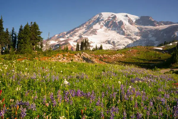
This beautiful and diverse trail system also offers spectacular views of the Cascade Mountain Range and is located on the south end of town, on Elm Street across from Whychus Creek. A 25-mile descent that is incredibly beautiful and changes terrain many times, the McKenzie River Trail is perfect for the experienced mountain biker.
From lava beds to green, lush and mossy forest, this trail provides incredible variety and an epic opportunity to see beautiful wildlife and Central Oregon’s natural terrain changes. If you are an avid biker, the full 25-mile trail may be right up your alley (just make sure to take two cars for shuttling).
But if you want to check out this fantastic trail and are just beginning to mountain bike or prefer less intense terrain, you may want to stick with biking the last 15 miles of the trail–the first 15 miles are more technical and challenging. After you’re done, you can visit Belknap Hot Springs for a quick soak to ease your sore muscles!
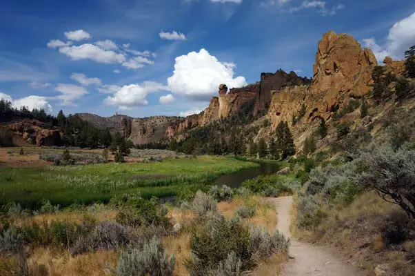
If you haven’t visited Smith Rock before, this is a must-see! Depending on the time of year, the dramatic rock formation, located just outside of Redmond, Oregon, and about 20 miles from FivePine Lodge & Spa, is an absolutely worthwhile excursion for either hiking or mountain biking.
But, this trail is not for the inexperienced mountain biker. Including lots of sharp descents, ridges, and exposed areas, the trail system at Smith Rock is perfect for experienced mountain bikers. But, don’t let that deter you! If you don’t bike it, hike it instead. Misery Trail is famous for the steep ascent, with breathtaking panoramic views at the top. Many of us who live in Bend ride all winter long.
Some ride fat bikes and COTA grooms trails at Wanoga Snow Park for that. It can be a fun change from riding on dirt. I prefer dirt, however. My ideal ride is a long loop in the desert. We have several areas to choose from: Maston and Cline Buttes, Horse Ridge, and Smith Rock are a few.
Many riders start in the Smith Rock State Park Parking lot. You will need a permit to park there—they can be purchased on-site if you don’t have one. Ride down the trail to the river, cross the footbridge and take a left. If it is a busy day, you will encounter many hikers. Please be very courteous, in fact even walk some. Those trails get a lot of pressure and they don’t want bikes to be shut out.
As you get further from the bridge, the number of hikers diminishes quickly, and by the point where the Crooked River starts flowing north, the hikers almost disappear.
As you continue on, you will come to the most technical part of the ride. It’s an uphill section on a scree slope. Be careful, but it is mostly rideable. You will be on the back side of the cliffs that you saw from the parking lot. Now you’re at the start of a long climb that includes 17 switchbacks, with eye-popping views.
Tips To Keep in Mind
Many bikers can ride all of the switchbacks, but the last two are trickier than they appear. One more steep climb, and you will have arrived at the top of Burma Road. Many cyclists ride up the Burma road. From the top of Burma you are leaving Smith Rock State Park and entering BLM land. The trail is long traverse to Gray Butte that gets no sun in the dead of winter, so watch out for ice.
After a couple of miles, you will come to the Cole Creek loop trail that takes off to the right. It crosses a road and heads downhill. On a good day, this is a super-fun descent of about two miles. This trail can also be icy or even muddy. When you get to the bottom, cross the road and continue on the trail to the Skull Hollow trailhead.
Look to the left, and you will take the Cole Creek trail that goes east. This trail will have more horse use but it is mainly a nice uphill. This avoids the steep road climb towards Gray Butte, but it adds about half an hour of riding time. After about three miles you will be riding parallel to a road. Be careful not to follow this trail too far. You will cross a main road and then take left, which will take you up to the old Orchard homestead and the Gray Butte trail head.
You will now take the trail back toward Smith Rock.
Note: The sign says Smith Rock 7.5 miles, but it is actually 11 miles back to the parking lot.
You will climb about 400 ft and then mainly descend as you loop around Gray Butte. When you come to a gate, go through it. In about a mile. After a couple of fun descents, you will return to where you finished the traverse and descended to Skull Hollow. Then just retrace your route back to the starting point.
Practice your switchbacks on the way down, and watch out for the hikers as you get close to the finish. The climb from the bridge to the parking lot is killer, the last bit being over 20%. This ride takes me about four hours, and it is 27 miles long. Enjoy!
Oregon is filled with famous mountain bike destinations and iconic trails. Big-name destinations include places like Bend, Oakridge, Hood River, and more… all places you’ve most likely heard of. With 5 IMBA Epics (both past and present), individual trails like the North Umpqua River Trail and other epics (whether or not they’re acknowledged by IMBA) like the McKenzie River Trail are constantly on the lips of mountain bikers from across the nation.
But all of those destinations? All of those epics? They’re found in the western half of Oregon.
Who’s heard about mountain biking in Northeast Oregon? Almost nobody… except for you, right now, and the other people who have read this guide. If you want to discover an untapped mountain bike paradise with a fraction of the trail traffic found in other places in Oregon, visit Cox Pass trail in Oregon.
Northeast Oregon is a wild and sparsely-populated area of the nation, with mountains ranging from rolling hills to jagged, rocky peaks. The area is dominated by the Blue Mountains and the Wallowa Mountains, but unfortunately for mountain bikers, most of the Wallowas are protected by the expansive Eagle Cap Wilderness—the largest wilderness area in Oregon.
While mountain bikes may be banned, the Wilderness Area does make for great hiking and peak climbing! And aside from some small swathes of wilderness, the Blue Mountains are largely open to mountain biking.